
Laurentian Channel Marine Protected Area Regulations (SOR/2019-105)
Full Document:
- HTMLFull Document: Laurentian Channel Marine Protected Area Regulations (Accessibility Buttons available) |
- XMLFull Document: Laurentian Channel Marine Protected Area Regulations [24 KB] |
- PDFFull Document: Laurentian Channel Marine Protected Area Regulations [341 KB]
Regulations are current to 2026-06-14
Table of Contents
Laurentian Channel Marine Protected Area Regulations
SOR/2019-105
Registration 2019-04-15
Laurentian Channel Marine Protected Area Regulations
P.C. 2019-339 2019-04-12
Her Excellency the Governor General in Council, on the recommendation of the Minister of Fisheries and Oceans, pursuant to subsection 35(3) of the Oceans ActFootnote a, makes the annexed Laurentian Channel Marine Protected Area Regulations.
Return to footnote aS.C. 1996, c. 31
Interpretation
Marginal note:Definition of Marine Protected Area
1 (1) In these Regulations, Marine Protected Area means the area of the sea that is designated by section 2.
Marginal note:Geographical coordinates
(2) In the schedule, all geographical coordinates (latitude and longitude) are expressed in the North America Datum 1983 (NAD 83) reference system.
Marginal note:Geographical coordinates for points
(3) The geographical coordinates of the points referred to in sections 2 and 3 are set out in the schedule.
Designation
Marginal note:Marine Protected Area
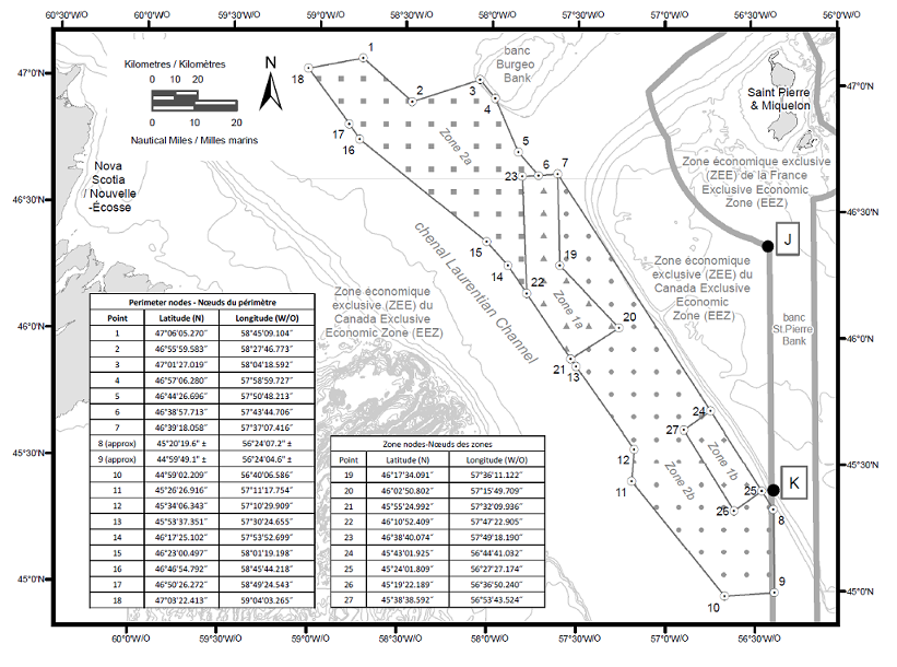
2 (1) The area of the sea depicted in the schedule that is bounded by the following lines is designated as the Laurentian Channel Marine Protected Area:
(a) a series of rhumb lines drawn from points 1 to 8;
(b) a geodesic line drawn from point 8 to point 9; and
(c) a series of rhumb lines drawn from points 9 to 18 and then back to point 1.
Marginal note:Seabed, subsoil and water column
(2) The Marine Protected Area consists of the seabed, the subsoil to a depth of five metres and the water column above the seabed.
Management Zones
Marginal note:Description
3 The Marine Protected Area consists of the following management zones, each of which is depicted in the schedule:
(a) Zone 1a, which is bounded by a series of rhumb lines drawn from point 6 to point 7, then to points 19 to 23 and then back to point 6;
(b) Zone 1b, which is bounded by a series of rhumb lines drawn from points 24 to 27 and then back to point 24;
(c) Zone 2a, which is bounded by a series of rhumb lines drawn from points 1 to 6, then to point 23, then to point 22, then to points 14 to 18 and then back to point 1; and
(d) Zone 2b, which is bounded by
(i) a series of rhumb lines drawn from point 7 to point 24, then to point 27, then to point 26, then to point 25 and then to point 8,
(ii) a geodesic line drawn from point 8 to point 9, and
(iii) a series of rhumb lines drawn from points 9 to 13, then to point 21, then to point 20, then to point 19 and then back to point 7.
Prohibited Activities
Marginal note:Prohibition
4 It is prohibited to carry out any activity in the Marine Protected Area that disturbs, damages, destroys or removes from the Marine Protected Area any living marine organism or any part of its habitat or is likely to do so.
Exceptions
Marginal note:Permitted activities
5 Despite section 4, the following activities may be carried out in the Marine Protected Area:
(a) the navigation of vessels provided that there is no anchoring in Zone 1a or 1b;
(b) fishing, other than commercial fishing, that is authorized under the Aboriginal Communal Fishing Licences Regulations;
(c) the laying, maintenance and repair of cables in Zones 2a and 2b, provided that it is not likely to destroy the habitat of any living marine organism in the Marine Protected Area;
(d) any activity that is carried out for the purpose of public safety, national defence, national security, law enforcement or responding to an emergency; and
(e) any activity that is part of an activity plan that has been approved by the Minister.
Activity Plan
Marginal note:Submission to Minister
6 (1) Any person may submit to the Minister an activity plan for the carrying out of scientific research or monitoring or educational activities in the Marine Protected Area.
Marginal note:Content of plan
(2) The activity plan must contain
(a) the person’s name, address, telephone number and email address;
(b) if the activity plan is submitted by an institution or organization, the name of the individual who will be responsible for the proposed activity and their title, address, telephone number and email address;
(c) the name of each vessel that the person proposes to use to carry out the activity, its state of registration and registration number, its radio call sign and the name, address, telephone number and email address of its owner, master and any operator;
(d) a detailed description of the proposed activity and its purpose, the methods or techniques that are to be used to carry out the activity and the data to be collected;
(e) the geographical coordinates of the site of the proposed activity and a map that shows the location of the activity within the boundaries of the Marine Protected Area;
(f) the proposed dates and alternative dates on which the activity is to be carried out;
(g) a list of the equipment that is to be used, the means by which it will be deployed and retrieved and the methods by which it is to be anchored or moored;
(h) a list of the type and quantity of samples that are to be collected;
(i) a list of any substances that may be deposited during the proposed activity in the Marine Protected Area — other than substances that are authorized under the Canada Shipping Act, 2001 to be deposited in the navigation of a vessel — and the quantity and concentration of each substance;
(j) a description of the adverse environmental effects that are likely to result from carrying out the proposed activity and of any measures that are to be taken to monitor, avoid, minimize or mitigate those effects;
(k) a description of any scientific research or monitoring activity or educational activity that the person has carried out or anticipates carrying out in the Marine Protected Area; and
(l) a general description of any study, report or other work that is anticipated to result from the proposed activity and its anticipated date of completion.
Marginal note:Approval of activity plan
7 (1) The Minister must approve an activity plan if
(a) the scientific research or monitoring activities set out in the plan are not likely to destroy the habitat of any living marine organism in the Marine Protected Area and
(i) will serve to increase knowledge of the habitat of any living marine organism or the biodiversity or the ecosystem structure and function of the Marine Protected Area, or
(ii) will serve to assist in the management of the Marine Protected Area; and
(b) the educational activities set out in the plan
(i) are not likely to damage, destroy or remove from the Marine Protected Area any living marine organism or any part of its habitat, and
(ii) will serve to increase public awareness of the Marine Protected Area.
Marginal note:Approval prohibited
(2) Despite subsection (1), the Minister must not approve an activity plan if
(a) any substance that may be deposited during the proposed activity is a deleterious substance as defined in subsection 34(1) of the Fisheries Act, unless the deposit of the substance is authorized under subsection 36(4) of that Act; or
(b) the cumulative environmental effects of the proposed activity, in combination with any other past and current activities carried out in the Marine Protected Area, are such that the activity is likely to destroy the habitat of any living marine organism in the Marine Protected Area or adversely impact the biodiversity or the ecosystem structure and function of the Marine Protected Area.
Marginal note:Timeline for approval
(3) The Minister’s decision in respect of an activity plan must be made within
(a) 60 days after the day on which the plan is received; or
(b) if amendments to the plan are made, 60 days after the day on which the amended plan is received.
Marginal note:Post-activity report
8 (1) If the Minister approves an activity plan, the person who submitted it must provide the Minister with a post-activity report within 90 days after the last day of the activity. The report must contain
(a) the data collected during the activity;
(b) the type and quantity of any sample that was collected, the date of collection and the geographic coordinates of the sampling site;
(c) an evaluation of the effectiveness of any measures taken to monitor, avoid, minimize or mitigate the adverse environmental effects of the activity; and
(d) a description of any event that occurred during the activity and that was not anticipated in the activity plan, if the event could result in the disturbance, damage, destruction or removal from the Marine Protected Area of any living marine organism or any part of its habitat.
Marginal note:Studies, reports or other works
(2) The person must also provide the Minister with a copy of any study, report or other work that results from the activity and is related to the conservation and protection of the Marine Protected Area. The study, report or other work must be provided within 90 days after the day on which it is completed.
Coming into Force
Marginal note:Registration
9 These Regulations come into force on the day on which they are registered.
SCHEDULE(Subsections 1(2) and (3), subsection 2(1) and section 3)Laurentian Channel Marine Protected Area
Page Details
- Date modified: